

Millions of people from Texas to Kansas will need to keep an eye on the sky Tuesday as the region braces for the return of severe weather. FOX Weather Meteorologist Britta Merwin breaks down the latest forecast on Monday, April 21, 2025.
The threat of severe weather will return to portions of the central U.S. this week, days after deadly storms that produced flooding rain, hail and tornadoes pummeled the Plains over the Easter weekend.
Three people were killed in Oklahoma during the extreme weather – one during a tornado in Spaulding and two due to flooding when their vehicle washed away in Moore.
-

This image shows damage to the City of Columbia Material Recovery Facility after severe weather on Sunday, April 21, 2025.
(Columbia, MO Fire Department/Facebook) -
This image sows tornado damage in Spaulding, Oklahoma.
(Hughes County Emergency Management/Facebook) -

This image sows tornado damage in Spaulding, Oklahoma.
(Hughes County Emergency Management/Facebook) -

A common theme throughout the Fayetteville community is yet another house with the roof partially ripped away.
(@ColbyEffect / X) -

The roof of an Arkansas home has been ripped apart due to the extreme winds.
(@ColbyEffect / X) -

A home in a Fayetteville neighborhood had its front two windows ripped away from the house’s structure. Two large windows have been covered.
(@ColbyEffect / X) -

A rough scene in Arkansas as a possible tornado ripped through communities throughout the state.
(@ColbyEffect / X) -

A funnel cloud was spotted in Camdenton, Missouri on Sunday during tornado-warned storms.
(Daniel Carnahan) -

At least two people, including a 12-year-old boy, were killed after their vehicle was washed away by flooding in Moore, Oklahoma, on Saturday, April 19, 2025.
(KWTV) -

Storm damage in Garrett County, Maryland on Saturday, April 19, 2025.
(Garrett County OEM / 911 Communications) -

Storm damage in Garrett County, Maryland on Saturday, April 19, 2025.
(Garrett County OEM / 911 Communications) -

Storm damage in Grantsville, Maryland on Saturday, April 19, 2025.
(Garrett County OEM / 911 Communications) -

Storm damage in Grantsville, Maryland on Saturday, April 19, 2025.
(Garrett County OEM / 911 Communications) -

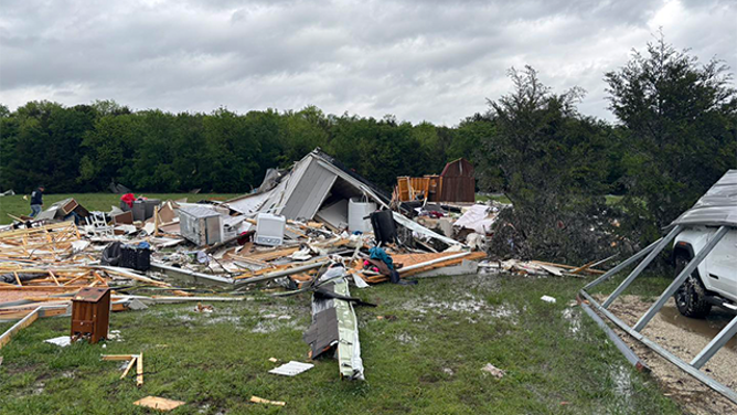
This image shows damage that occurred during severe weather in Jacksboro, Texas, on Saturday, April 19, 2025.
(@scr0sX/X) -

This image shows damage that occurred during severe weather in Jacksboro, Texas, on Saturday, April 19, 2025.
(@scr0sX/X) -

This image shows damage that occurred during severe weather in Jacksboro, Texas, on Saturday, April 19, 2025.
(@scr0sX/X) -

Tornado damage in Ada, Oklahoma on April 19, 2025.
(Charlotte Rebecca Allen/Facebook) -

Tornado damage in Ada, Oklahoma on April 19, 2025.
(Charlotte Rebecca Allen/Facebook) -

Tornado damage in Ada, Oklahoma on April 19, 2025.
(Charlotte Rebecca Allen/Facebook) -

This image shows a tornado near Hico, Texas, on Saturday, April 19, 2025.
(@DrChrisWJackson/X)
Now, residents across the region will only have a day to catch their breath and clear debris before the threat of powerful thunderstorms returns.
The FOX Forecast Center said the threat of storms and flooding rain will ramp up starting Tuesday afternoon, with the highest threat being located across portions of West Texas and western Oklahoma.
“I have to be honest, this is a classic setup,” FOX Weather Meteorologist Britta Merwin said. “It’s a dryline setup. So, if you’re a local, you know exactly what we’re talking about.”
DOWNLOAD THE FREE FOX WEATHER APP
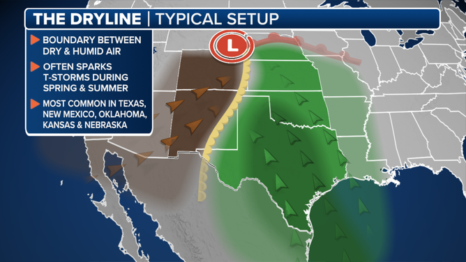
This graphic explains a dryline.
(FOX Weather)
A dryline is a boundary between a dry air mass and a humid one that is usually found in the central and southern Plains during the spring and summer months. It usually advances eastward in the afternoon hours and retreats westward during the evening hours.
“This is a setup where you start to see these towering thunderstorms that build up in the afternoon,” Merwin continued. “And the afternoon heat is part of the instability. Once that dryline sets up, the thunderstorms are igniting, and they progress out towards the east. But, guess what? The dryline retreats back in the overnight, and you reload for the next day.”

(FOX Weather)
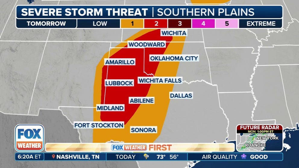
NOAA’s Storm Prediction Center (SPC) has highlighted areas of Texas from the U.S.-Mexico border through Kansas in the central Plains where strong to severe thunderstorms could develop Tuesday.
However, nearly 2 million people have been placed in a Level 2 out of 5 threat of severe weather on its risk scale.
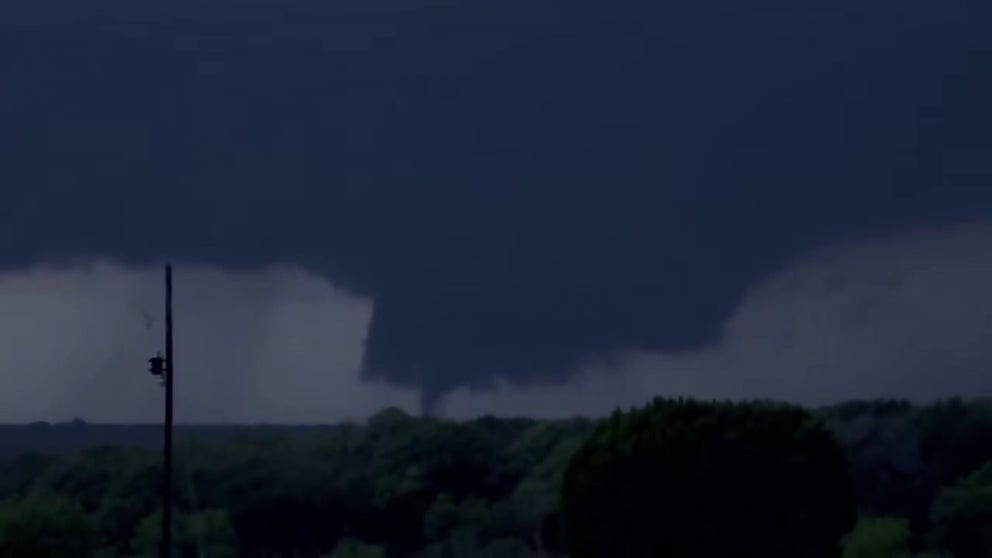
A dramatic video recorded near the community of Hico, Texas, shows a tornado touching down during severe weather on Saturday, April 19, 2025.
This includes cities such as Lubbock, Amarillo, Midland and Odessa in Texas, as well as Hutchinson in Kansas.
Hail and damaging winds will be the main threats from any severe thunderstorms that develop Tuesday, but there is also a low chance of some tornadoes.